
Importo totale (1 articolo articoli):
Destinazione ordine:

bart metselaar (25 risultati)
Vai alla pagina principale dei risultati di ricerca
Tipo di articolo
- Tutti gli articoli
- Libri (25)
- Riviste e Giornali
- Fumetti
- Spartiti
- Arte, Stampe e Poster
- Fotografie
- Mappe
-
Manoscritti e
Collezionismo cartaceo
Condizioni
Legatura
- Tutte
- Rilegato
- Brossura (12)
Ulteriori caratteristiche
- Prima edizione
- Copia autografata
- Sovraccoperta
- Con foto (6)
- No print on demand
Paese del venditore
Valutazione venditore
-
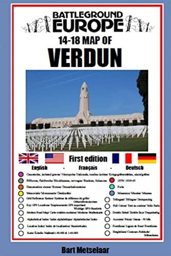
Verdun (Map) (Battleground Europe Maps)
Editore: Pen and Sword Military, 2020
ISBN 10: 1526768208ISBN 13: 9781526768209
Libro
Map. Condizione: New. *Brand new* Ships from USA.
-
![Immagine del venditore per Verdun (Map) (Battleground Europe Maps) by Metselaar, Bart [Map ] venduto da booksXpress](https://pictures.abebooks.com/inventory/md/md30797839258.jpg)
Verdun (Map) (Battleground Europe Maps) by Metselaar, Bart [Map ]
Editore: Pen and Sword Military, 2020
ISBN 10: 1526768208ISBN 13: 9781526768209
Libro
No Binding. Condizione: new.
-
Verdun Map Battleground Europe Maps
Editore: Pen and Sword Books Ltd, 2020
ISBN 10: 1526768208ISBN 13: 9781526768209
Libro
PAP. Condizione: New. New Book. Shipped from UK. Established seller since 2000.
-
Verdun (Map) Format: Map
Editore: Casemate Publishing, 2020
ISBN 10: 1526768208ISBN 13: 9781526768209
Libro
Condizione: New. Brand New.
-

Verdun (Map) (Paperback)
Editore: Pen & Sword Books Ltd, South Yorkshire, 2020
ISBN 10: 1526768208ISBN 13: 9781526768209
Libro
Paperback. Condizione: new. Paperback. For many years the Holts have provided tourers to the battlefields with excellent mapping for the Ypres Salient and the Somme. This map of the Verdun/Meuse area fills one of the many gaps in the coverage of the Western Front. This map of the Verdun battlefield is in the same style, using a colour coded system to distinguish the different types of features. It includes some 300 locations of memorials, cemeteries, significant remnants of the battle terrain, remaining fortifications, trenches, the destroyed villages and other vestiges of the war. On the reverse there is a cut out and enlarged section of the Verdun battlefield in particular - the most visited part of the area, which provides greater detail. This section includes the Ossuary at Douamont, Forts Douamont, Vaux and Souville and many more features. The front line at key stages of the battle in 1916 is clearly indicated GPS references are given for the more signifiant sites. Roads and major tracks are shown, with restrictions in access as known at the date of publication. The map extends from the eastern fringes of the Argonne Forest to the west and encompasses the whole of the 1916 Verdun battlefield to the east. This means that several places of interest to the student of the American army's offensive in late 1918 are shown. The map is tri-lingual - in English, French and German - so far as is practicable given the constraints of space. The map is of a manageable size, both in a vehicle and when being used outside. AUTHOR: Bart Metselaar has been visiting the battlefields of the Western Front for over twenty years, from his late teens. He has spent much time walking the battlefields of the Western Front and has acquired an encyclopaedic knowledge of the ground and the surviving remnants of the war. An amateur cartographer, he has produced the mapping for a number of Pen and Sword Battleground Europe books. He has been working on this Verdun map for some years, painstakingly searching out memorials that have been all but forgotten. He is now turning his attention to the Arras battlefield. 1 colour map Comprehensive mapping for the Battle of Verdun 1916 and a sizeable part of the early days of the Meuse-Argonne Offensive 1918. Clearly produced in full colour, with different types of feature in different colours, all supported by two comprehensive keys. Shipping may be from multiple locations in the US or from the UK, depending on stock availability.
-
Verdun (Map)
Editore: Pen & Sword Books Ltd 2020-05-30, Barnsley, 2020
ISBN 10: 1526768208ISBN 13: 9781526768209
Libro
paperback. Condizione: New. Language: eng.
-
Verdun: Battleground Europe Map
Editore: Pen and Sword Military, 2020
ISBN 10: 1526768208ISBN 13: 9781526768209
Da: Naval and Military Press Ltd, Uckfield, Regno Unito
Valutazione venditore:

Libro
Published â Aug. 2020Published Price ÂŁ4.99 For many years the Holts have provided tourers to the battlefields with excellent mapping for the Ypres Salient and the Somme. This map of the Verdun/Meuse area fills one of the many gaps in the coverage of the Western Front.This map of the Verdun battlefield is in the same style, using a colour coded system to distinguish the different types of features. It includes some 300 locations of memorials, cemeteries, significant remnants of the battle terrain, remaining fortifications, trenches, the destroyed villages and other vestiges of the war. On the reverse there is a cut out and enlarged section of the Verdun battlefield in particular - the most visited part of the area, which provides greater detail. This section includes the Ossuary at Douamont, Forts Douamont, Vaux and Souville and many more features.The front line at key stages of the battle in 1916 is clearly indicatedGPS references are given for the more signifiant sites. Roads and major tracks are shown, with restrictions in access as known at the date of publication.The map extends from the eastern fringes of the Argonne Forest to the west and encompasses the whole of the 1916 Verdun battlefield to the east. This means that several places of interest to the student of the American army's offensive in late 1918 are shown.The map is tri-lingual - in English, French and German - so far as is practicable given the constraints of space. The map is of a manageable size, both in a vehicle and when being used outside.
-
Paperback. Condizione: Brand New. map edition. 8.39x5.59x0.08 inches. In Stock.
-
Verdun (Map) (Battleground Europe Maps)
Editore: Pen and Sword Military, 2020
ISBN 10: 1526768208ISBN 13: 9781526768209
Libro
Condizione: New. In.
-
Verdun (Map) (Battleground Europe Maps)
Editore: Pen & Sword Military, 2020
ISBN 10: 1526768208ISBN 13: 9781526768209
Libro
Map. Condizione: New. BRAND NEW ** SUPER FAST SHIPPING FROM UK WAREHOUSE ** 30 DAY MONEY BACK GUARANTEE.
-
Verdun (Map) (Battleground Europe Maps)
Editore: Pen and Sword Military, 2020
ISBN 10: 1526768208ISBN 13: 9781526768209
Libro
Condizione: New. .
-
Verdun (Map) (Battleground Europe Maps)
Editore: Pen and Sword Military, 2020
ISBN 10: 1526768208ISBN 13: 9781526768209
Libro
Paperback. Condizione: new. Buy for Great customer experience.
-
Verdun (Map) (Battleground Europe Maps)
Editore: Pen and Sword Military, 2020
ISBN 10: 1526768208ISBN 13: 9781526768209
Libro
Condizione: New. Book is in NEW condition. 0.1.
-
Verdun (Map)
Editore: Pen & Sword Books Ltd, 2020
ISBN 10: 1526768208ISBN 13: 9781526768209
Da: Kennys Bookshop and Art Galleries Ltd., Galway, GY, Irlanda
Valutazione venditore:

Libro
Condizione: New. 2020. Map. . . . . .
-
Condizione: New. 2020. Map. . . . . . Books ship from the US and Ireland.
-
Verdun (Map) (Battleground Europe Maps)
Editore: Pen and Sword Military, 2020
ISBN 10: 1526768208ISBN 13: 9781526768209
Libro
Paperback. Condizione: new. New Copy. Customer Service Guaranteed.
-
Verdun (Map) (Battleground Europe Maps)
Editore: PEN AND SWORD MILITARY, 2020
ISBN 10: 1526768208ISBN 13: 9781526768209
Libro
Condizione: new.
-
Paperback. Condizione: Brand New. map edition. 8.39x5.59x0.08 inches. In Stock.
-
Verdun (Map)
Editore: Pen & Sword Books Ltd Aug 2020, 2020
ISBN 10: 1526768208ISBN 13: 9781526768209
Libro
Taschenbuch. Condizione: Neu. Neuware - For many years the Holts have provided tourers to the battlefields with excellent mapping for the Ypres Salient and the Somme. This map of the Verdun/Meuse area fills one of the many gaps in the coverage of the Western Front. Englisch.
-
Verdun Map Battleground Europe Maps
Editore: Pen and Sword Books Ltd, 2020
ISBN 10: 1526768208ISBN 13: 9781526768209
Libro
PAP. Condizione: New. New Book. Shipped from UK. Established seller since 2000.
-

Verdun (Map) (Paperback)
Editore: Pen & Sword Books Ltd, South Yorkshire, 2020
ISBN 10: 1526768208ISBN 13: 9781526768209
Libro
Paperback. Condizione: new. Paperback. For many years the Holts have provided tourers to the battlefields with excellent mapping for the Ypres Salient and the Somme. This map of the Verdun/Meuse area fills one of the many gaps in the coverage of the Western Front. This map of the Verdun battlefield is in the same style, using a colour coded system to distinguish the different types of features. It includes some 300 locations of memorials, cemeteries, significant remnants of the battle terrain, remaining fortifications, trenches, the destroyed villages and other vestiges of the war. On the reverse there is a cut out and enlarged section of the Verdun battlefield in particular - the most visited part of the area, which provides greater detail. This section includes the Ossuary at Douamont, Forts Douamont, Vaux and Souville and many more features. The front line at key stages of the battle in 1916 is clearly indicated GPS references are given for the more signifiant sites. Roads and major tracks are shown, with restrictions in access as known at the date of publication. The map extends from the eastern fringes of the Argonne Forest to the west and encompasses the whole of the 1916 Verdun battlefield to the east. This means that several places of interest to the student of the American army's offensive in late 1918 are shown. The map is tri-lingual - in English, French and German - so far as is practicable given the constraints of space. The map is of a manageable size, both in a vehicle and when being used outside. AUTHOR: Bart Metselaar has been visiting the battlefields of the Western Front for over twenty years, from his late teens. He has spent much time walking the battlefields of the Western Front and has acquired an encyclopaedic knowledge of the ground and the surviving remnants of the war. An amateur cartographer, he has produced the mapping for a number of Pen and Sword Battleground Europe books. He has been working on this Verdun map for some years, painstakingly searching out memorials that have been all but forgotten. He is now turning his attention to the Arras battlefield. 1 colour map Comprehensive mapping for the Battle of Verdun 1916 and a sizeable part of the early days of the Meuse-Argonne Offensive 1918. Clearly produced in full colour, with different types of feature in different colours, all supported by two comprehensive keys. Shipping may be from our Sydney, NSW warehouse or from our UK or US warehouse, depending on stock availability.
-

Verdun (Map) (Paperback)
Editore: Pen & Sword Books Ltd, South Yorkshire, 2020
ISBN 10: 1526768208ISBN 13: 9781526768209
Libro
Paperback. Condizione: new. Paperback. For many years the Holts have provided tourers to the battlefields with excellent mapping for the Ypres Salient and the Somme. This map of the Verdun/Meuse area fills one of the many gaps in the coverage of the Western Front. This map of the Verdun battlefield is in the same style, using a colour coded system to distinguish the different types of features. It includes some 300 locations of memorials, cemeteries, significant remnants of the battle terrain, remaining fortifications, trenches, the destroyed villages and other vestiges of the war. On the reverse there is a cut out and enlarged section of the Verdun battlefield in particular - the most visited part of the area, which provides greater detail. This section includes the Ossuary at Douamont, Forts Douamont, Vaux and Souville and many more features. The front line at key stages of the battle in 1916 is clearly indicated GPS references are given for the more signifiant sites. Roads and major tracks are shown, with restrictions in access as known at the date of publication. The map extends from the eastern fringes of the Argonne Forest to the west and encompasses the whole of the 1916 Verdun battlefield to the east. This means that several places of interest to the student of the American army's offensive in late 1918 are shown. The map is tri-lingual - in English, French and German - so far as is practicable given the constraints of space. The map is of a manageable size, both in a vehicle and when being used outside. AUTHOR: Bart Metselaar has been visiting the battlefields of the Western Front for over twenty years, from his late teens. He has spent much time walking the battlefields of the Western Front and has acquired an encyclopaedic knowledge of the ground and the surviving remnants of the war. An amateur cartographer, he has produced the mapping for a number of Pen and Sword Battleground Europe books. He has been working on this Verdun map for some years, painstakingly searching out memorials that have been all but forgotten. He is now turning his attention to the Arras battlefield. 1 colour map Comprehensive mapping for the Battle of Verdun 1916 and a sizeable part of the early days of the Meuse-Argonne Offensive 1918. Clearly produced in full colour, with different types of feature in different colours, all supported by two comprehensive keys. Shipping may be from our UK warehouse or from our Australian or US warehouses, depending on stock availability.
-
Condizione: New. Comprehensive mapping for the Battle of Verdun 1916 and a sizeable part of the early days of the Meuse-Argonne Offensive 1918. Clearly produced in full colour, with different types of feature in different colours, all supported by two comprehensive keys.
-
Verdun (Map) (Battleground Europe Maps)
Editore: Pen and Sword Military, 2020
ISBN 10: 1526768208ISBN 13: 9781526768209
Libro
Paperback. Condizione: new. Brand New Copy.
-
Verdun (Map) (Battleground Europe Maps)
Editore: Pen and Sword Military, 2020
ISBN 10: 1526768208ISBN 13: 9781526768209
Libro
Paperback. Condizione: new. New.